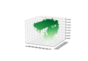
Lidar data visualization
From wikiluntti
Introduction
Use Lidar data, post analyze it with Python/ Pandas? and use Blender to visualize it.
Theory
The free Lidar data set are available e.g. at Opentopography.org. We use both, the Tif data and LAS data of IT-Ren, Fluxnet site
LAS File Format
LAS@Wikipedia how to print lidar file format las
a) Headers.
b) VLR: Variable Length Record. Include 1) header and 2) payload.
c) Point records. Different point formats 0-10.
LAS in Python

[Laspy Github] [LasPy]
import numpy as np
import pylas

las = pylas.read( fname )
#np.all(las.user_data == las['user_data'])

point_format = las.point_format
print( point_format )
print( point_format.id )
print( list(point_format.dimension_names) )

from mpl_toolkits import mplot3d
import matplotlib.pyplot as plt
fig = plt.figure()
ax = plt.axes(projection='3d')

N=5000
ax.scatter3D(las.X[:N], las.Y[:N], las.Z[:N], c=las.Z[:N], cmap='Greens');
Interpolate Lidar Data
[[1]]