Sinuosity of Kemijoki: Difference between revisions
| Line 14: | Line 14: | ||
Kemijoki 4.png|Missing only 1 km, but because the river curves so eccentric, it skips many kilmometers. By zooming it is easy to see that a lot of meandering is missing. | Kemijoki 4.png|Missing only 1 km, but because the river curves so eccentric, it skips many kilmometers. By zooming it is easy to see that a lot of meandering is missing. | ||
Kemijoki 5.png|Taking 2.5 km out of the measuring stick, we gain 30 km of river length. | Kemijoki 5.png|Taking 2.5 km out of the measuring stick, we gain 30 km of river length. | ||
Kemijoki 6.png|Finally, using a 100 m strides we will arrive rather close to the GIS measure. | |||
</gallery> | </gallery> | ||
== Theory == | == Theory == | ||
Revision as of 21:01, 26 April 2026
Introduction
Use Python to estimate the sinuosity of Kemijoki.
The river was obtained from https://download.geofabrik.de/europe/finland.html but only one river (Kemijoki) with one branch is used. The extracting method is described elsewhere.
Kemijoki
-

Kemijoki is 550 km long according to Wikipedia. This dataset contains 500.20 km of river.
-
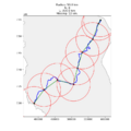
Kemijoki measured with 50 km measure stick. The distance doesn't exactly match up, and the last 12 km is missing.
-

By cutting the measuring stick to half, we get one measure (25 km) more length. It still skips many of the meandering.
-

More distance and curves are achieved.
-

Missing only 1 km, but because the river curves so eccentric, it skips many kilmometers. By zooming it is easy to see that a lot of meandering is missing.
-
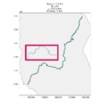
Taking 2.5 km out of the measuring stick, we gain 30 km of river length.
-
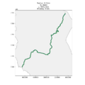
Finally, using a 100 m strides we will arrive rather close to the GIS measure.


